Ridge Walk or Valley Route: Two Ways to Read a Landscape
Ridge walk or valley route: see how height, weather and terrain shape the experience, then choose a walk that suits your plans and the landscape.
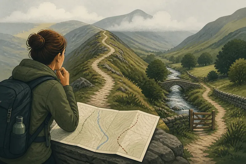
You unfold a ridge walk or valley route on a map at the kitchen table, then notice the contour lines crowding around one option and the stream beside the other. The choice shapes what the landscape lets you see: a ridge brings its structure into view, while a valley keeps you close to its working details.
What does a ridge walk show you?
From a ridge, the country becomes a set of relationships. You can follow the line of a river, see where roads cross open ground and notice how settlements sit in sheltered hollows. A summit or saddle may also give you a useful reference point as the path rises and falls.
Distance is less legible than shape. A village that looks close can lie beyond a deep dip, and a distant peak may be hard to identify once cloud arrives. The view is a little like a map spread across a table: the arrangement is clear, but the small print is not.
Open ground brings its own conditions. Wind may be stronger, and cloud can hide landmarks or reduce the view. A ridge may be clear when the valley below is shaded, or the reverse; local forecasts and route information matter more than a hopeful glance out of the window.
What do you notice in a valley?
A valley route offers fewer long views and more detail at walking pace. A bridge, culvert, gate or dry-stone wall is not a mark from above but part of the route itself. Paths may follow a stream, road or field edge, giving you a recurring line to watch.
Sound and ground add clues. Running water can indicate a nearby crossing, while exposed stones or damp soil may mark a change in surface. High banks and bends can conceal the next section, though, so a clear stream is not a substitute for checking a junction.
Trees and steep sides can provide shade and shelter, but may make a long stretch feel enclosed. A valley route can also be muddy or slippery. Conditions depend on the particular path, not simply on its lower position.
How do the routes differ for navigation?
A ridge often makes broad orientation easier: a distinct summit, coastline or line of hills can stay in view. A valley may offer a continuous feature such as a stream or road. Neither makes every turn obvious. Similar-looking spurs can confuse a ridge walk; bridges and branching tracks can complicate a valley path.
Before setting out, compare a current map with local route information. Mark the junctions where the path changes direction, then identify features you can recognise on the ground. On a ridge, these might be a saddle or summit. In a valley, they might be a bridge or the point where a track leaves the water.
A phone map can help confirm a decision at a junction. A printed map makes surrounding contours and neighbouring paths easier to compare at a glance. Check weather, access and any local notices before choosing an exposed section or water crossing; conditions and signs can change.
How should you choose a ridge walk or valley route?
Start with what you want the walk to make visible, then check the route against the day’s conditions and your plans. A broad view may suit an outing centred on the shape of the land. A streamside path may suit one focused on crossings, boundaries and changes in vegetation.
- View and exposure: If the route has open sightlines and the forecast suits exposed ground, consider the ridge; if not, compare a lower alternative and check its conditions too.
- Landmarks: If a ridge has distinct peaks or saddles, use them as references; if the outline is indistinct, choose a route with clearer mapped features.
- Water and crossings: If a valley path includes bridges or stream crossings, check their locations and local notices; if a crossing appears unsuitable, use a permitted alternative rather than improvising.
- Surface: If the route description mentions muddy or uneven ground, check whether your footwear and walking plans suit it; if they do not, choose a better-suited path.
- Shelter: If shade and cover are useful, compare a tree-lined valley route; if it is exposed to waterlogged ground or poor visibility, reconsider it rather than assuming lower means easier.
- Junctions: If the map shows several forks or spurs, note them before setting out; if you cannot identify the next turn on the ground, stop and check the map instead of guessing.
Say you have a free afternoon, a map showing a marked stream path and a ridge spur, and a forecast of low cloud over the upper slopes. First, you check local notices and see no closure on either route. Next, you compare the junctions and confirm that the stream path follows the mapped water through two bridges, while the ridge spur has an exposed section and a less distinct return. If your aim is to trace the valley’s crossings, the stream route offers the clearer fit; if the cloud lifts and the ridge route’s exposure suits your plans, the spur remains an option. The decision changes what you can observe, not the weather.
What details reward a slower pace?
On a ridge, look at how the land falls away on either side. A shallow fold may hold the start of a stream; a saddle can explain why a path passes between two higher points. Compare roads and field boundaries with the slope, rather than treating the panorama as a row of distant landmarks.
In a valley, watch what repeats and what interrupts it. A stream may slip beneath a bridge and reappear farther along. Trees may follow a field boundary instead of the water. A shift from open pasture to woodland can make the valley’s changing use as visible as its changing shape.
At a safe stopping place, turn around and look back. A bend or summit may seem different from the return direction, revealing which features were helping you keep your bearings. There is no need to interpret a landscape while negotiating a slippery step; the landscape will wait.
Which route suits common plans?
Is a ridge walk always harder than a valley route?
No. Difficulty depends on slope, surface, exposure and the route itself. A valley path can be steep or slippery, while a ridge track may be broad and gradual.
Which route suits landscape photography?
A ridge can frame layers of hills and broad changes in cloud. A valley can bring reflections, bridges and woodland edges closer; choose for the subjects and conditions you want to work with.
Can a valley route help with wayfinding?
It can, especially where a stream or road provides a continuous reference. Check each crossing and junction, since the most obvious branch may not be the route you intend to follow.
What should you do if cloud covers the ridge?
Check the forecast and local route information before deciding whether the exposed path remains suitable. A lower route may offer more shelter and close detail, but check its surface, access and crossings too.
Can one walk include both landscapes?
Some paths climb from a valley to a ridge and return by another route. Others have a short spur to a viewpoint above a stream. A map can help you compare the junctions and terrain, but account for the climb and changing conditions rather than treating the high section as a free extra.
At different levels, the same features change character. A farm that looked like a few pale marks from above may resolve into separate fields and lanes below. From the ridge, the stream that seemed to occupy the whole valley becomes one line among several. A ridge walk or valley route is most useful when its terrain suits the day and gives you a clear reason to look again at the land around you.